SYDNY
SYDNEY
HomeGeophysicsMASW / VS30 (velocidad de ondas de corte)

MASW / VS30 Testing in Sydney – Shear Wave Velocity Profiling

Rigorous testing. Clear reporting.

LEARN MORE

Sydney sits on the Triassic Sydney Basin, a sequence of Hawkesbury Sandstone, Ashfield Shale, and Quaternary alluvium. The city's population exceeds 5.3 million, and many suburbs lie on deep soil profiles over bedrock. MASW surveys measure shear wave velocity (VS) from surface waves to map stiffness contrasts. This is critical for seismic design under AS/NZS 1170.4. The VS30 parameter — the average shear wave velocity in the top 30 metres — classifies sites from Class A (hard rock) to Class E (soft soil). Without it, designers cannot determine the correct spectral shape for earthquake loads. Combining MASW with a dilatometer test provides complementary stiffness data at depth, while microtremor HVSR confirms resonance frequencies independently.

Illustrative image of MASW / VS30 (shear wave velocity) in Sydney
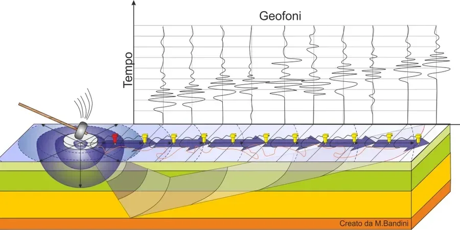
MASW provides a continuous VS profile from a single surface line — no boreholes needed. It is the fastest method for site class assignment in the Sydney Basin.

Our service areas

Scope of work

MASW uses a linear array of geophones and a surface source. The recorded Rayleigh wave dispersion curve is inverted to produce a 1D VS profile. In Sydney, the technique is applied in three main contexts:
  • Seismic site classification – VS30 values determine the site sub-soil class per AS 1170.4:2024, directly affecting base shear calculations.
  • Depth-to-bedrock mapping – MASW identifies the impedance contrast where VS exceeds 700–800 m/s, marking engineering bedrock.
  • Liquefaction screening – low VS layers in alluvial valleys like Parramatta River indicate loose, saturated sands susceptible to cyclic softening.
The survey is non-invasive and can be deployed on pavements, slopes, or existing structures. Active MASW reaches 30–50 m depth; passive MASW (ambient noise) reaches deeper, down to 200 m. Both methods are run under AS 1289. When a detailed stratigraphic profile is needed, results can be cross-checked with a seismic refraction tomography survey to resolve P-wave and S-wave velocities together.
Technical reference — Sydney

Area-specific notes

In Sydney, a common pitfall is assuming a single VS30 value from a MASW line represents an entire block. The geology under the CBD changes from Hawkesbury Sandstone to Ashfield Shale within 200 metres. A site near the Harbour may show Class B rock, while a site 100 metres inland sits on Class C residual soil. We have seen projects where a single MASW profile was used to design foundations for a whole precinct — then later boreholes revealed a channel of soft Tuggerah Formation clay that was missed. Always plan multiple MASW lines in areas with known geological variability.

Need a geotechnical assessment?

Reply within 24h.

Email: contact@geotechnicalengineering1.co

Standards used

AS/NZS 1170.4:2024 (Structural Design Actions – Earthquake Actions), AS 1289/D4428M-14 (Standard Test Method for Crosshole Seismic Testing), NEHRP Recommended Seismic Provisions (BSSC, 2020) – VS30 site class definitions

Technical parameters

ParameterTypical value
VS30 range measured180–900 m/s (Class E to Class A)
Array length (active)24–72 geophones at 1–3 m spacing
Depth of investigation30–200 m (active + passive combined)
Frequency content2–80 Hz (Rayleigh wave dispersion)
Field productivity3–6 line-km per day (2-person crew)
Uncertainty in VS30±15% with good dispersion curve quality

Quick answers

What VS30 value separates Class C from Class D in AS 1170.4?

Class C (shallow soil) has VS30 between 300 and 600 m/s. Class D (deep or soft soil) has VS30 between 180 and 300 m/s. Sites below 180 m/s fall into Class E (very soft soil).

How deep does MASW need to go to get a reliable VS30?

The array length must be at least 30 m for active MASW. To resolve the top 30 m, the farthest geophone should be 30–45 m from the source. Passive arrays require a radius of 50–100 m to reach 200 m depth.

Can MASW be done on steep slopes in Sydney?

Yes. MASW works on slopes up to 30 degrees. The geophones are placed along the contour or parallel to the slope. The dispersion curve is inverted using a 2D model that accounts for topography.

What is the typical cost range for a MASW survey in Sydney?

The cost ranges between AU$2,460 and AU$5,310 depending on line length, number of lines, and site access. A single 48-channel active line with interpretation starts near the lower end.

Location and service area

We serve projects across Sydney and its metropolitan area.

View larger map